A year ago, when I joined Laterite as a Research Analyst, I had only worked with traditional survey data from in-person or telephone interviews. I had no experience working with remote sensing data collected for example by sensors, satellites, phones, drones. Since joining I have been lucky to have substantial exposure to a treasure trove of geospatial datasets and methods that complement traditional data collection, and allow researchers to measure outcomes of interest in remote, hard-to-reach areas. If you’re interested in geospatial data and its applications for development, but you don’t know where to start, allow me to share how I developed an interest in working with this type of data.
1. An intro to geospatial data via Worldpop
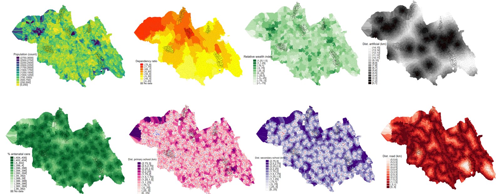
My first exposure to geospatial data came in the form of Worldpop. Worldpop offers open access spatial-demographic (among other) datasets for countries around the world. With this data, it’s possible to estimate population counts in a high-resolution grid, using machine learning methods and information from remotely sensed data (e.g., settlements, land cover, building maps, health facilities, satellite nightlights). Fascinating stuff for a health economist such as myself. But also useful and applicable in cases where detailed population estimates are not available – for instance, in targeting social programs and understanding rural-urban population dynamics.
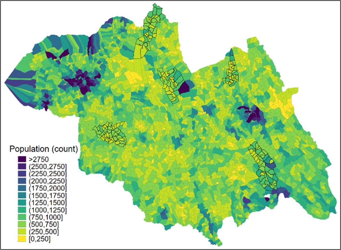
Figure 1. Worldpop-based population counts in Northern province of Rwanda by village
2. A chance to apply geospatial data for development in a study in Central Kenya
From there, I was involved in a study of remoteness (distance from cities), coffee-farming productivity in Kenya. The expectation is that more remote farmers experience higher costs, and have less access to markets, due to their relative isolation. This would negatively impact their productivity. We saw some evidence of this in our analyses, though the results were not conclusive. For this study, I found that it was possible to use Stata to estimate geo-routed distances (not linear, but by car or foot) from coffee-farming households and urban centres to provide more accurate estimates of remoteness than linear distances.
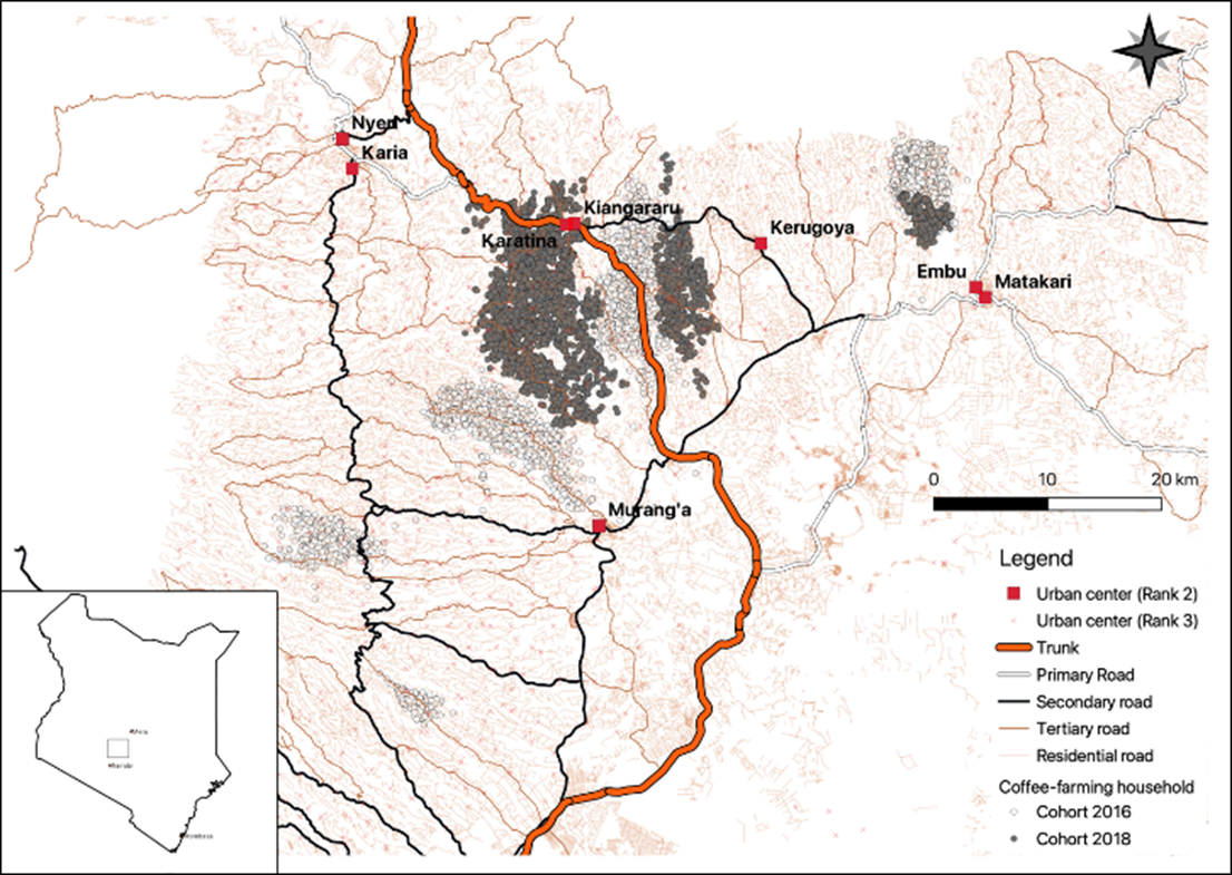
Figure 2. A map of the area of study in Central Kenya
3. Learning from others in the field
Building on this experience, I had the good fortune to attend the World Bank’s Measuring Development 2022 Mobile Data in Global Development Research. This was a golden opportunity to see the forefront of using remote-sensing data to find evidence-based solutions for development challenges. Here’s a short list of some of the presentations I found interesting:
- Researchers at the University of California (UC), Berkeley, the University of Mannheim and Northwestern University used machine learning and phone data to better target humanitarian aid in Togo, in a study featured in Nature.
- Researchers at UC, Berkeley used phone and satellite data of crops to study seasonal labour flows in Afghanistan during poppy harvesting seasons.
- The World Bank studied the impact of mobile network expansion in Africa on infant mortality, using exogenous variation in lighting strike intensity as an instrument for network expansion to obtain a causal estimate.
- A researcher from the UC, Berkeley used mobile data and satellite imagery, combined with surveys and stool sample collection, to study whether the distance from meat farms and slaughterhouses was a risk factor for antibiotic resistant E. Coli in a small area of households near the capital Quito, in my native Ecuador.
- The World Bank tracked disparate impacts of COVID-19 on self-isolation, commuting and migration in developing countries using very high frequency mobile data.
4. Next steps: incorporating geospatial data into more of our work
This is a very exciting time for applied researchers. With the increase of remote-sensing devices, coupled with an increase in computing power and the availability of geospatial datasets, the use of these types of data can only be expected to increase in the future.
At Laterite, we are keenly aware of this, and we are taking steps to develop staff capacity and data infrastructure to include insights from this valuable data as part of the work we produce for our clients. For me, this has just been the beginning of a fascinating journey into the world of GIS and how we can use it to build an evidence base that more effectively addresses development challenges.
This blog post was written by Jose Rubio-Valverde, Associate Economist and GIS enthusiast